TULIP is a smart city project delivery and research program led by the University of Technology Sydney (the Faculty of Engineering and IT and the Institute for Sustainable Futures). We are working at the front line of the emerging smart city space in Australia, in collaboration with a broad coalition of partners from local, state and federal government, industry, research and civil society.
Our mission is to harness the Internet of Things to build better, more liveable cities, where people are placed at the heart of solutions. Technologies must be designed, integrated and delivered around the needs of communities.
We recognise that urban liveability outcomes can be leveraged through the widespread collection and sharing of environmental data. To do this, we are deploying public access networks and sensors in cities around NSW, supported by an innovative new approach to data architecture. We are filling the environmental data 'void' by collecting real-time, hyper-local data on things like urban heat, air quality, noise and stormwater.
TULIP is a blueprint for local governments and communities to design, build and deliver smart city infrastructure on their own terms. Our approach to data architecture is collaborative, modular, open, flexible, network-agnostic and capable of aggregating any type of data from across a city in one place - or pushing it somewhere else if you'd prefer. It's the antidote to proprietary systems and vendor lock-in that we think is absolutely critical for local government that are serious about their smart city potential.
Melrose Park: Smart planning for climate responsive neighbourhoods
Smart planning for Climate Responsive Neighbourhoods was a 20-month project led by the City of Parramatta Council, in partnership with the University of Technology Sydney, PAYCE, mProjects, the urban institute [ui!], and ESRI Australia, with significant grant support from the Australian Government, through the second round of the Smart Cities and Suburbs program. The project commenced in November 2018 and was completed in June 2020.
The project explored the application of real-time low-cost environmental sensing technology to four critical-use cases at Melrose Park, on the eastern edge of the City of Parramatta. The area is a mixture of residential and light industrial zones on the northern side of the Parramatta River and is dominated by a 30-hectare brownfield site, formally a light industrial park, now under development by PAYCE. The new Melrose Park development is being constructed over a 10-year period and is expected to include up to 10,000 new residences as well as mixed commercial and retail space. The development features a significant number of new buildings, extensive parkland and tree canopy cover, as well as new transport links. Combined with the significant growth in local population resulting from new residences, the liveability of the area is expected to change substantially as the site develops and matures. By monitoring the local microclimate at Melrose Park, the project sought to establish a baseline of environmental data, against which future changes can be compared. The provision of real-time data, aggregated from multiple sources, also supported a range of experimental operational outcomes for the management and future planning of the development. The project worked closely with the local community, exploring citizen’s concerns about environmental liveability and delivering novel and accessible new technologies, such as an open community LoRaWAN network and a public data discovery dashboard.
Melrose Park | Smart City video on YouTube
Smart Liveable Neighbourhoods: Lake Macquarie/City of Sydney
The Smart Liveable Neighbourhoods for Lake Macquarie and City of Sydney project was delivered by the University of Technology Sydney (UTS) in partnership with Lake Macquarie City Council (LMCC) and the Council of City of Sydney, with major funding from the Australian Government. The Australian Government’s $50 million Smart Cities and Suburbs Program (SCSP) supports the delivery of innovative smart city projects that improve the liveability, productivity and sustainability of cities and towns across Australia. This project was one of 49 round one SCSP grant recipients and had a total delivery value of $866,000. The project commenced on the 17th of November 2017 and ran to the 30th of June 2019.
An overview of specific project activities and deliverables
Open access LoRaWAN for community participation and scalability
The project trialled the deployment of three Meshed LoRaWAN gateways that make use of The Things Network, an open access free-to-use community IoT service that provides open connectivity for both Council and community devices. This has directly enabled community engagement with Council’s smart city development via project initiatives such as the Smart Liveable Neighbourhoods Challenge and Adopt-a-sensor.
Exploring and understanding low-cost sensor options
We procured a broad range of commercially available devices and tested them for functionality, reliability and the ability to integrate and manage them successfully with a city-wide network. This practical experimentation has supported a deep working knowledge of the operational considerations and constraints of working with a variety of commercially available devices.
Developing our own multi-sensor device
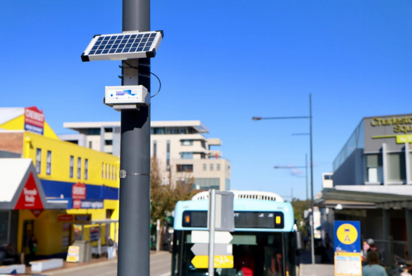
Working with ARCS Group, we developed the TULIP EMS to deliver a combination of environmental data and functionality that was not available anywhere else. The process of developing our own monitoring solution has deepened our understanding of smart city sensors and provided Council partners with a robust scalable solution. Additionally, we have developed an integration between the EMS and a solid-state weather station (Lufft WS10) to provide extended meteorological telemetry, all with a self-contained solar/battery system and LoRaWAN connectivity.
Benchmarking sensors
Researchers at UTS have benchmarked the performance of commercially available environmental sensors against high-end equipment in a controlled lab environment. We built our own test chamber to carry out this work and have begun work defining a benchmarking protocol and device categorisation framework. The TULIP EMS has been a major focus, with the benchmarking work helping to validate the performance of our new device.
Designing and delivering sensor networks to generate new data
We have deployed over 100 sensors that remain active after the end of the project, measuring temperature, humidity, air quality, noise, weather and people counts. We have explored a range of practical and experimental considerations relating to the choice of location and mounting options and the capturing and management of associated metadata. The data which these networks are now generating is unprecedented in Lake Macquarie and Sydney. Our extensive review of smart city literature has confirmed that the scale of these new networks is both nationally and internationally significant.
Building an open modular data architecture
We have built TULIP as an example of an open modular data architecture, integrating four separate cloud-based data platforms. It is one answer to the proliferation of closed proprietary smart city systems that Councils are accumulating. In this project, TULIP is drawing data from multiple sensor types on multiple networks. It is providing a single onboarding and management solution for all of these devices, displaying all of the data in a single location and making it available to a range of different users, in a controlled and sophisticated way. This is done not through one mega-platform solution, but via an ecosystem of collaborators filling different niches. The modular nature of the platform gives Councils greater freedom to work with multiple partners and build an architecture that best suits their needs.
Understanding the role of data models to facilitate interoperability and data sharing
A data model is the framework, language and rules that govern how data is interpreted, stored, labelled, accessed and shared. TULIP has developed a shared data model between all of our platform partners. It has enabled us to capture and manage the complex metadata required to support rigorous environmental data science. It also allows interoperability and user functions that leverage capacities from multiple platforms simultaneously.
The project has generated an open public data portal and an open public API for sharing live data with the world. At the heart of this capacity lies a data model that in part references existing standards and in part, through necessity, offers new structures and approaches that might have wider relevance.
Understanding and testing use cases for smart sensor technology
Too often, smart city projects end up being led and defined by technology. This project was designed by exploring use cases, placing the needs of Council and community front and centre. We have learnt a great deal about the collaborative design processes that underlie human-centred smart city initiatives and we have identified a broad range of practical use cases for environmental sensor technologies. This project has enabled us to explore some of these use cases, while many others have planted seeds across Council for future attention.
Developing Council’s operational capacity (device deployment and management)
The scale of the sensor networks deployed in this project has demanded that we develop an operational practice for planning, deployment, and device management. We have developed scalable procedures for identifying deployment locations, prepping devices and mounting kits for installation, capturing metadata, testing and verifying devices and monitoring them for issues. These lessons and new capabilities provide Council with a practical operational foundation from which to scale smart city device deployments in future.
Data actuated installations for place-making and engagement
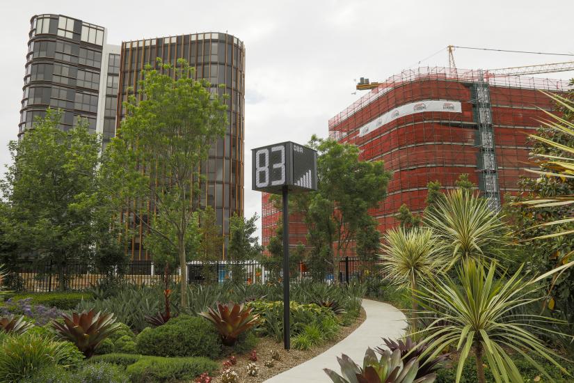
Working with Newcastle-based start-up Newie Ventures, we developed the TULIP Rosella, a versatile open-source device that responds to live data from the TULIP platform and generates custom LED light patterns. The Rosella has been adapted to drive three data-actuated public artworks in Lake Macquarie which each respond to some combination of temperature, rain, wind and weather warnings. The artworks activate public space, bring data to life, and engage communities with the dynamic nature of the environment and with technology.
Understanding user requirements for environmental data platform functionality
Detailed project design brought together Council end users with platform developers to explore what an ideal environmental data platform might look like. The process has helped Council to understand and prioritise their own needs and has helped the commercial partners to understand things from a functional client perspective. Many assumptions about the relative importance of particular functionality have been put aside and many critical new functions have come to light that were not previously apparent.
Exploring new environmental data for better city living
The sensor networks have begun to generate usable environmental data, enabling researchers at UTS to begin to make sense of it. Three teams have explored urban heat, air quality and noise data in turn. The work has been necessarily limited due to the small amount of data accumulated so far, but we have been able to begin the process of verifying data quality and identifying significant trends and patterns. Perhaps the most useful output of this early data research is an assessment of what the new data might mean for Council going forward, with a number of future avenues of inquiry identified.
Engaging community with smart technology: building ownership, digital literacy and environmental awareness
The Smart Liveable Neighbourhoods Challenge was a community competition to design and build a working LoRaWAN device that connected to The Things Network via one of the new LoRaWAN gateways funded by the project. Participants were challenged to create solutions that might be deployed in public spaces to benefit the whole community. Five finalists presented working devices with functions such as measuring noise, counting people, and monitoring sports fields.
The Adopt-a-Sensor program was a major part of device deployment for the Smart Liveable Neighbourhoods project. Ten schools, four sports facilities, a scout hall and 15 local residents have been gifted devices by Council and deployed them on their properties. These devices all connect to the TULIP platform, alongside Council devices. This model demonstrates a potential emerging model for distributed community ownership of environmental sensors. There is potential here for future scalability. In the shorter term, the approach has proven to be a highly effective way of engaging people with the project, the technology and the environmental liveability challenges that we are addressing.
Exploring future scalability and business models
A guiding approach of TULIP has been to design and test systems and operations that can be scaled to support much larger device deployments and more complex data utilisations than those undertaken within the scope of this project. A challenge has been that business models which might support scaled commercial activities have not always been apparent to Council while things are smaller scale and experimental. The agile and experimental nature of the project has given Council the freedom to explore multiple complex aspects of the technologies, use cases and user requirements. Ideas have been tested, and knowledge generated through practical engagement. Now these learnings are directly informing strategic discussions as Council considers the next phase of its smart city journey.
RESEARCH OUTPUTS
TULIP Network (Website)
Building a Climate Responsive Neighbourhood: A report on low-cost environmental monitoring at Melrose Park (2020) (Report)
Smart Liveable Neighbourhoods in Lake Macquarie and City of Sydney (2020) (Report)
Researchers
-
 Senior Research Consultant
 -
 Research Principal
 -
 Senior Research Consultant